With ITineris, based on GPS technology, you can track your farm vehicles
from anywhere and at any time. The tracking system allows you to analyse
and optimise fleet movements and performance, which in turn improves
productivity indicators.
ITineris
GPS-based fleet tracking system
Efficiency – Control – Savings
Features
-
Vehicle activity tracking
GPS-based radio vehicle identification (agroID) with tracking function
provides you with second-by-second positioning of your vehicles. You can
track movement data on the online map in real time. E.g. direction of
movement, speed and location on own field maps. -
Fuel consumption monitoring
The constant monitoring of fuel consumption allows you to check the
extent and location of refuelling, and to detect the amount, time and
location of fuel withdrawals. This makes it possible to measure the exact
fuel costs of agricultural work. -
Warning, alarm
Set up this function to receive automatic alerts by e-mail and SMS in case
of field abandonment, approach or fuel level changes and equipment
malfunction. -
Periodic report of area-based works
You can monitor seed and spray usage (double-spray rows), work quality
(adherence to row spacing, work speed) and field working time efficiency
on a daily, weekly, monthly and yearly basis on your own field maps. -
Vehicle driver tracking - driver identification
With driver identification, it is possible to retrace who did what, when, and
where. This improves work discipline, accurate accounting and production
efficiency, and reduces the use of machines in foreign areas. -
Quality assurance in transport and agriculture
Thanks to automatic documentation of the routes travelled by vehicles and
the transports they completed, you can see at any time where the driver
has been and when, how much time they spent with customers or
delivering goods, and even provide information on the estimated time of
arrival. -
Vehicle data and analysis
With detailed analysis of real-time and retrievable data, you can record
vehicle operating time and fuel consumption, and eliminate unnecessary
trips and waiting. -
Report module
Periodic report of area-based works.
Monitor the work performed, the size of the area, and the quality of the work on your own maps (observance of line spacing, speed of work) and efficiency of working time in field.
The system sends automatic statements by e-mail daily, weekly, monthly, and even yearly.
Based on your own idea, edit on your own demand.
THE LATEST ITineris WayQuest PROGRAMMING VERSION 3.8.2
Installation package
[76,5 MB]
Before installation, all critical Windows updates must be installed. To install
SQL Server, you will need Microsoft .NET Framework versions 2.0, 3.5
and 4.0, or updates to these. The updates are carried out in several steps,i.e. after installation, a reboot is required and then the Windows Update
page must be revisited and run again. In our experience, it can take up to
4-5 reboots to get everything up and running. Without these, the SQL
server will not install and the ITineris program will not run. Always back up
the program database before upgrading!
If you feel necessary, please ask one of our colleagues to help you
upgrade!
Hardware devices
Atlas
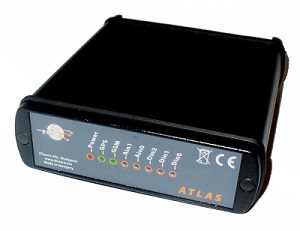
This device operates in the vehicle. It is primarily used to track the movement of the vehicle, record its route and additional data. It includes the GPS receiver, which determines the position with the help of the GPS antenna placed in the vehicle, and also calculates the vehicle’s coordinates, speed and direction of travel, and records data describing this movement, thereby allowing the movement of the vehicle to be followed. The device also contains a GSM modem, which can be used to establish a GPRS connection with the central server operated by ITineris Kft.
AgroID + RFGW
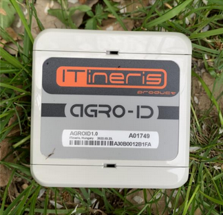
Radio frequency machine identification. The tool automatically recognizes the machine and selects the work process assigned in the system. It makes administration easier and the engine operator does not have to deal with it. It is also suitable for user identification.